

17 October - 21 November
Where do I begin? How does anyone adequately sum up 5 weeks spent amongst some of the most majestic mountain scenery on earth? In mid-October, Rachel, Betsy, and I departed Kathmandu, and after 8 stomach churning hours aboard a bus in the Himalayan foothills we arrived in the market town of Jiri. From there it was our legs and lung capacity guiding us higher and higher toward the roof of the world, Sagarmatha (aka Chomolungma in Tibetan, Everest in English).

The first 9 days of the trek, which led us from Jiri to Namche Bazar were mostly Himalayan flat. That means, not flat at all, but starting and ending each day at approximately the same elevation. For example, on the first day of the trek, we climbed 2000 feet, descended 3300 feet, ate lunch, and then climbed another 3300 feet to Deurali, arriving at our lodge just before sundown. I think all of us agree that this portion of the trek was some of the most demanding hiking we have ever done in our lives.

This section of trail crosses 3 major passes, numerous rivers, and passes hundreds of Buddhist prayer walls and chortens with prayer flags strung everywhere. The scenery is dramatic. Agricultural terraces of rice, buckwheat, or corn festoon hillsides for thousands of vertical feet. Dense conifer forests dotted with maples and oaks in fall colors drape hillsides, and late blooming flowers soak up the fall’s final rays of sun. This section of trail is not heavily traveled until just below Namche Bazaar, and gave us a glimpse of what trekking in the Everest was like decades ago. We arrived in Namche Bazaar with strong legs, and in need of a couple of days of rest.

It was from just above Namche, hiking up the Khumbu Valley, where we gained our first clear views of the high Himalayas. As we inched our way higher and higher, grand peaks loomed in every direction. It seemed as if each turn in the trail revealed new and ever more spectacular mountain scenery. This is a landscape that makes you feel insignificant and, by comparison, other mountain landscapes the world over seem small.

Each of us was attracted to different mountains in this part of the trek. It seems quite funny to initiate a trek to Everest but be unable to take your eyes off of surrounding peaks such as Ama Dablam, Tabuche, and Pumo Ri (all small when compared to giants like Everest or Lhotse). Make no mistake; this part of the trek is inhospitable to man.
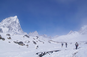
With each step up the air became colder and the available oxygen became scarcer. By the time we reached our high point, panting up the 18,200 foot mountain of Kala Patthar, only half of the oxygen available at sea level was present. Climbing higher and higher with throbbing heads, struggling for each breath, and fighting constant nausea--- we felt awful. At the same time we were awestruck at the cathedral of peaks, so close and clear, looming in all directions. It amazed us that when we stopped walking and enjoyed these views the effects of altitude would suddenly disappear.

On clear evenings we shivered contentedly as we watched the sunset and the alpenglow glowing orange on the earth’s highest mountain. At dusk, as the last light faded, we witnessed Everest, Lhotse, Nuptse, and countless other peaks against a background of purple twilight. However beautiful, as we left our highest sleeping point at Gorakshep (16,960 feet) and packed up our frozen water bottles, we were happy to head lower down the Khumbu Valley.

On a steep, narrow, vertigo-inducing trail we left the Khumbu Valley and headed toward the Gokyo Lakes. Over the course of three days of trekking we regained the elevation we had lost and entered the Gokyo Valley.

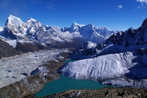
We were now on the opposite (west) side of numerous mountains now familiar to us. The landscape in this area appears drier, more open, and the massive Cho Oyo (at 26,800 feet, the world’s 6th highest mountain), is prominent in nearly every view. Each of the Gokyo Lakes is a turquoise gem. In the still, early morning light these azure waters feature unreal reflections of high mountains-truly a photographer’s dream.

In the Gokyo area, Everest and its neighbors are at a fair distance, and one gains a real perspective of the highest mountain on earth. From the nearly 18,000 foot peak, Gokyo Ri, and the stark landscape surrounding the 5th Gokyo Lake, there is no question that Everest is the roof of the world.
From Gokyo, it was an uneventful walk down to Lukla over the course of five days, where we were to catch a flight back to Kathmandu on the 28th day of the trek. With the exception of one snowstorm, which serendipitously hit on one of our only rest days, we had been graced by fine, clear, magnificent weather. I guess it is safe to assume that we had exhausted our good weather karma. Planes cannot land in Lukla when it is cloudy. Waiting for the weather to clear, stranded in Lukla, five days had passed and very few planes had departed. On the sixth day we awoke to clear skies and a chance to fly, but bad weather in Kathmandu kept planes grounded. To put it nicely, there are a million places other than Lukla where I would rather be stranded for a week. On Day 7 (another cloudy day), feeling desperate and contemplating walking 7 days back to the nearest road in Jiri we called, Santaman, the owner of Nepal Trek Guide (our trekking agency in Kathmandu), and pleaded “Charter us a helicopter and get us out of here, we have had enough,”. Our helicopter was scheduled to arrive in the early afternoon and had to depart before 4:30pm to get to Kathmandu before dark. At 3pm it started to rain and they decided that no more helicopters would land in Lukla that day. Waiting at the helipad in misty rain, faced with another miserable night in Lukla (home to the world’s nastiest bathroom-located right in our guesthouse), Santaman worked a miracle. Our wonderful guide Dev said “We move to Surkhe, where the heli will land in one hour”. Grabbing all of our gear we literally ran downhill for an hour in the rain on slippery rocks, dodging Lukla’s open sewers, and arrived breathless at the helipad/cow pasture in the tiny village of Surkhe with 10 minutes to spare. The cows were moved aside, our helicopter landed, we boarded at 4:15pm, and we soared over the misty Himalayan countryside back to Kathmandu.

After 10 days without a shower we are clean and well-fed. Today sadly parted ways with Betsy (who is headed to the beach in Thailand) and our new friend Tony who shared every excruciating moment of Lukla with us, and flew to Delhi, India. In a couple of days, Rachel’s sister, Sarah, and her cousin, Kevin, will join us for a few weeks, glimpsing the color and clamor of Northern India (Taj Mahal, here we come).


0 comments:
Post a Comment